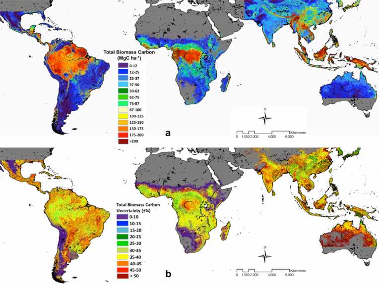
Tropical forests store carbon in the wood and roots of their trees, and now NASA has created a map that shows where and how much carbon is stored in these forests. The map is seen as a a baseline for carbon research and monitoring efforts, and as a tool for managing global carbon dioxide.
The map shows that the tropical forests that store the most carbon are in Latin America. The map covers forests in over 75 countries and was made using ground- and space-based data.
Lead researcher Sassan Saatchi explained in a press release: "This is a benchmark map that can be used as a basis for comparison in the future when the forest cover and its carbon stock change." He added "The map shows not only the amount of carbon stored in the forest, but also the accuracy of the estimate."
When trees are cut down, burned or when they decompose in the natural way, the stored carbon is released to the air. These processes contribute 15 to 20 percent of global carbon emissions.
To create the map, the NASA researchers used data from the Geoscience Laser Altimeter System lidar on NASA's ICESat satellite to determine how tall trees were. They used this information with data taken from ground measurements to calculate the amount of above-ground biomass of the forests, which corresponds to the amount of carbon they contained.
The map found that forests in the 75 tropical countries studied contained 247 billion tons of carbon at the start of this century, with forests in Latin America storing 49 percent of this carbon.
The map also shows the health and longevity of forests and helps researchers understand how the forests contribute to the global carbon cycle and overall functioning of the Earth system.
As a next step, the researchers will compare the carbon map with satellite observations of deforestation to find the hot spots where carbon dioxide is being released to the atmosphere.
The study was published May 30 in the Proceedings of the National Academy of Sciences.


