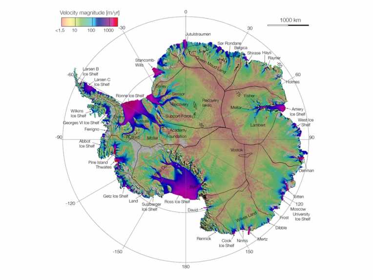
High above the earth, satellites are now mapping ice flows in the Antarctic, providing vital information on the progress of climate change for the first time.
NASA funded the researchers, who published their results this week in Science Express. The map they have created shows glaciers as they snake their way from the desolate Antarctic interior to the southern oceans.
"This is like seeing a map of all the oceans' currents for the first time. It's a game changer for glaciology," said Eric Rignot of NASA's Jet Propulsion Laboratory in Pasadena, and the University of California. "We are seeing amazing flows from the heart of the continent that had never been described before."Rignot and his colleagues Jeremie Mouginot and Bernd Scheuchl used a network of European, Japanese and Canadian satellites to build an accurate picture from billions of data points to see through cloud, avoid the glare of the sun and work around obstacles on land. Now, they've shaped their information into a map of glacial movements, including the vast East Antarctica which has never before been charted.
The team found new formations in the vast continent, including a ridge that splits the 5.4 million-square-mile (14 million-square-kilometre) landmass from east to west and unnamed glaciers moving at 800 feet a year towards the sea.
"The map points out something fundamentally new: that ice moves by slipping along the ground it rests on," said Thomas Wagner, NASA's cryospheric program scientist in Washington. "That's critical knowledge for predicting future sea level rise. It means that if we lose ice at the coasts from the warming ocean, we open the tap to massive amounts of ice in the interior."
Top Image and Video Credit: Antarctic Ice Flows © NASA/JPL-Caltech/UCI


